Updated June 29, 2021
Louisville may not be the first place that comes to mind when you think of incredible landscapes, but it sure is located perfectly for people who love the outdoors! With access to some of the best local green spaces, state parks, and national forests in Kentucky, Indiana, and Ohio, there are so many places to explore. Hiking near Louisville offers stunning mountain views, amazing waterfalls, striking gorges, and more. We created this guide to the best hikes near Louisville to inspire you to plan your next outdoor adventure!

Easy Hiking Near Louisville
Cherokee Park Scenic Loop Trail
- Distance from Louisville: 0 miles
- Trail Length: 4.8 miles
- Elevation Gain: 393 feet
As one of Louisville’s most beautiful outdoor trails, Cherokee Park’s Scenic Loop Trail is an excellent hiking trail for all levels of hikers. If you’re on a time crunch or simply don’t want to go far from the city, Cherokee Park is a fantastic place to immerse yourself in nature without the difficulty of strenuous trails or long drives. At the park, you’ll find forested trails with lots of local wildlife and a few more urban areas with statues, sidewalks, and fields. You’ll also find several scenic spots that boast wooden bridges and boardwalks throughout the park. For a quick jaunt into nature, Cherokee Park’s loop is one of the best hikes in Louisville.
Mount Saint Francis Loop Trail
- Distance from Louisville: 14 miles/20 minutes
- Trail Length: 2.8 miles
- Elevation Gain: 269 feet
The Mount Saint Francis Loop Trail is the perfect example of a trail that’s a perfect escape. While there aren’t any crazy views on this trail, the scenery is very peaceful and secluded, and you’ll get the feeling of full immersion in nature without going far from the city at all. Gorgeous lake views are aplenty here, and there are tons of lovely wooden bridges and boardwalks throughout the 2.8-mile stretch that bring you through the woods. It’s a very classic walk in the woods, and locals absolutely love it.

Wild Hyacinth Trail at Floyd’s Fork
- Distance from Louisville: 0 miles
- Trail Length: 2 miles
- Elevation Gain: 144 feet
For one of the easier hikes near Lousiville, the Wild Hyacinth trail has a surprising amount of variety. Located within Louisville’s city limits, this trail – located at Floyd’s Fork Parklands – has cliffs, creeks, forests, and meadows along just 2 miles. Perfect for families, beginners, and anyone seeking an easy, leisurely hike, you’ll get to see a wide variety of ecosystems and wildlife along the trail. There are also lots of small elevation changes for added challenge and fun!
Morgan Conservation Park
- Distance from Louisville: 34 miles/40 minutes
- Trail Length: 2.4 miles
- Elevation Gain: 265 feet
Locals absolutely love the trails at Morgan Conservation Park because they feel like “actual hiking.” Rather than the typical urban paved sidewalks and asphalt pathways, the trails here are pure, unadulterated dirt, and those who come here often cite this as one of their favorite perks. At the park, you’ll find abandoned wooden barns, wooden boardwalks, small creeks and waterfalls, and lots of wildflowers in the spring and summer. Additionally, there’s a little bit of elevation gain, which means you’ll have some added challenge and get some exercise, too!

Moderate & Difficult Hikes Near Louisville
Charlestown State Park Trail #6
- Distance from Louisville: 18 miles/30 minutes
- Trail Length: 2.3 miles
- Elevation Gain: 236 feet
Charlestown State Park is one of the most beloved parks for hiking near Louisville, and at around half an hour from the city, it’s super easy to get to. There are several numbered trails here, but one of the favorites by far is Trail #6, which brings hikers to waterfalls, lake views, and rocky outcroppings via stunning forest trails. Locals love this trail for its moderate length, slight challenge, and family-friendly environment.
If you’ve got extra time in the area and want some more adventure, head to the Rose Island abandoned amusement park to see some of the ruins of the former rides and pools that once stood there. It’s creepy but fascinating in a way!
Tioga Falls
- Distance from Louisville: 31 miles/35 minutes
- Trail Length: 1.9 miles
- Elevation Gain: 324 feet
Love them or hate them, we had to put the most popular waterfalls near Louisville on our list. Tioga Falls are an absolutely beautiful set of waterfalls located just over half an hour from the city, and it’s just a 2 mile out and back trail to see them.
When we say these are the Louisville area’s most popular falls, we mean it – this place gets crowded, and quickly. We’d recommend getting there early in the morning to avoid the crowds, or go on a weekday. To extend your hike, you can tack on the Bridges to the Past trail, which is located nearby on connected trails.
Scotts Gap Loop Trail
- Distance from Louisville: 22 miles/30 minutes
- Trail Length: 3.3 miles
- Elevation Gain: 639 feet
Located in Jefferson Memorial Forest, Scotts Gap Loop trail is a beloved moderate trail that offers a taste of some of the forest’s best attributes. With views of the surrounding mountains and moderately challenging trails to get there, this trail is a great step-up for beginners or a fun challenge for more experienced hikers. In just 3.3 miles, you’ll get ample opportunities for viewing local wildlife and will enjoy the serenity of the forest around you. Watch out for the climb in the very beginning of the trail – it’s the toughest part!

Elm Lick Trail
- Distance from Louisville: 25 miles/30 minutes (Bernheim Forest)
- Trail Length: 5 miles
- Elevation Gain: 646 feet
When you hear that Bernheim Forest is an arboretum, you probably think “trees.” Well, that’s true – there are thousands of trees in this heavily forested area – but there are also several fun surprises on this 5-mile trail. Along the pathways, you’ll climb nearly 650 feet across several small ascents and pass by an old silo, gnarly, warped trees, and a creek that’s quiet and peaceful. You’ll also have the chance to catch a few nice views of the forest from above!
Siltstone Trail
- Distance from Louisville: 30 miles/40 minutes (Jefferson Memorial Forest)
- Trail Length: 12.1 miles
- Elevation Gain: 2,211 feet
As the only truly strenuous trail on our list, the Siltstone Trail at Jefferson Memorial Forest is one of the longest and most rewarding trails in the park area. The trail climbs up a mountainside in the forest and runs along a ridgeline for several miles. While there aren’t too many crazy views or landmarks along the 12.1 miles of this trail, the real fun is in the hike itself – you’ll climb over 2,000 feet along the way and have a lot of fun trail challenges, like steep ascents and potential wildlife spotting. For a full day hike in the woods that will get you sweating, the Siltstone Trail is a fabulous option for experienced hikers.

Clifty Falls (Indiana)
- Distance from Louisville: 48 miles/1 hour
- Trail Length: 7 miles
- Elevation Gain: 1,164 feet
Clifty Falls State Park in Indiana is just an hour from Lousiville and offers wonderful, long trails for those looking for a moderate challenge. For a solid, 7-mile loop, the Clifty Falls, Hoffman Falls, and Tunnel Falls trail is a great starting point. On this trail, you’ll climb wooden stairs through the forest, passing by several waterfalls and creeks along the way. You’ll also pass next to (and underneath) gorgeous stone cliffsides that jut out from the earth. The Clifty Falls area is a magnificent landscape to explore with tons of variety and is one of the coolest hikes near Louisville!
Hemlock Cliffs National Scenic Trail
- Distance from Louisville: 52 miles/1 hour
- Trail Length: 1.2 miles
- Elevation Gain: 147 feet
Although it’s short, the Hemlock Cliffs trail is a spectacular hike through some of the fascinating rock formations and cliffs of southern Indiana. Located in Hoosier National Forest, this 1.2 mile hike takes hikers almost entirely alongside a rocky cliff area, complete with cave-like structures and bowl-shaped gorges. It’s a perfect spot for photos or for hikers to experience a totally otherworldly landscape without going too far from Louisville.

Gray’s Arch
- Distance from Louisville: 131 miles/2 hours
- Trail Length: 3.4 miles
- Elevation Gain: 580 feet
Perhaps one of the most stunning natural landmarks within driving distance of Louisville is Gray’s Arch in Daniel Boone National Forest, Kentucky. A 2-hour drive from the city, the Gray’s Arch Trail loop is one of the most jaw-dropping hikes near Louisville, taking intrepid hikers to a natural bridge formation called Gray’s Arch. Along the way, you’ll find wooden stairs, dirt paths, and lots of terrain changes as you make your way to the arch – a fun challenge that’s accessible to most hikers who are willing to put in the effort!

Auxier Ridge Trail
- Distance from Louisville: 134 miles/2 hours (Daniel Boone National Forest)
- Trail Length: 4.4 miles
- Elevation Gain: 908 feet
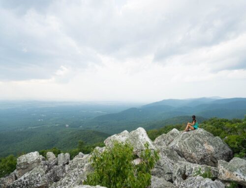
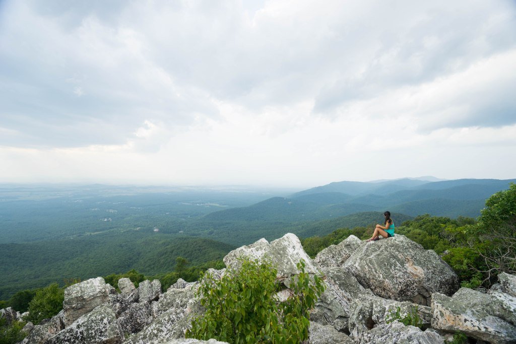
Daniel Boone National Forest is one of the most epic parks near Louisville, and is perfect for a day trip or a weekend adventure in the mountains. The Auxier Ridge Trail is one of the prettiest hikes near Louisville in this area, with 4.4 miles of trails that bring hikers to viewpoints of some of the area’s most striking rock formations, which stick out above the forest treetops. Views are the name of the game here, and you’ll hardly go a few minutes without seeing some kind of spectacular panorama along this trail.
We’d drive the 2 hours just to do this trail alone, but if you want to extend your hiking adventure, there are tons of other trails in Daniel Boone Forest you can check out as well.

Dog Slaughter Falls
- Distance from Louisville: 177 miles/2 hours, 45 minutes
- Trail Length: 2.6 miles
- Elevation Gain: 223 feet
Possibly one of the most photographed waterfalls in Kentucky is Dog Slaughter Falls, a scenic cascade located in Cumberland Falls State Park. Despite its horrific name, the waterfalls on this trail look like something out of a fairytale. With powerful falls that plunge into turquoise pools surrounded by unique rock formations, there’s a lot to see (and photograph!) on this 2.6-mile trail.
On the way to the falls, you’ll also pass by striking rock formations surrounded by trees that will leave you awe-struck. There aren’t many trails that have as much stunning scenery as Dog Slaughter Falls, and we’d absolutely recommend this hike for anyone willing to take on the challenge!
Additional Resources for Hiking Near Louisville
What to Pack
- Breathable hiking clothes – For warmer hikes, you’ll want to wear a sweat-wicking shirt and breathable pants, like these Patagonia hiking shorts for men and women. For cold-weather hikes, we recommend dressing in layers, including merino wool baselayers for men and women, a down puffer jacket for men and women, and a Northface waterproof outer shell for men and women (a must for hiking in Seattle). And don’t forget a pair of the best women’s and men’s hiking socks!
- Trekking poles – You won’t need these for every single hike, but we suggest throwing them in your car just in case. We recommend the Black Diamond Trail Ergo cork trekking poles, which are lightweight, easy to transport, and durable.
- Water bottle – Having water available at all times is a huge must. To limit disposable plastic, we recommend bringing your own refillable water bottle. We’re obsessed with Hydro Flask water bottles because they keep water cold for hours.
- Sunscreen and bug spray – Sweatproof sunscreen and DEET bug spray can help you avoid sunburn and bug bites, two of hiking’s most annoying after-effects. Our favorite kind of sunscreen is Sun Bum, as it is free of harsh chemicals and safe for marine life, including coral reefs.
- A brimmed hat or cap – The sun can be brutal in open hikes, so always pack a brimmed hat or cap for day hikes in the sunshine.
- Emergency blanket and first aid kit – We’d strongly recommend bringing a first aid kit and a lightweight emergency blanket on every hike. Why? Because the unfathomable can happen, and it’s always best to play it safe.
- Durable day pack – A durable day pack is the perfect spot to stash all your hiking gear. While any backpack will do, we recommend the Osprey Tempest 20 or the Talon 22 day packs because they’re comfortable and breathable for long hikes. For more information, check out our best day packs for any terrain guide.
Wondering what exactly you should pack for your next hike? Visit our Complete Day Hiking Packing List for our full list and our top gear recommendations.


