Updated August 5, 2025
For people who live in Sacramento, there are seemingly endless opportunities to get outdoors and explore. With great weather all year and access to fantastic outdoor areas like the Bay Area and Lake Tahoe, who wouldn’t want to take advantage? Hiking near Sacramento is one of the most beloved weekend activities for locals, and with the wide variety of trails and paths to try, it’s pretty easy to see why. We created this guide to some of the best hikes near Sacramento to help you plan your next outdoor adventure.

Easy Hiking Near Sacramento
Jedediah Smith Memorial Trail (American River Parkway)
- Distance from Sacramento: Runs through the city
- Trail Length: 28 miles total
- Elevation Gain: 541 feet
The Jedediah Smith Memorial Trail, also known as the American River Parkway, is a walking, running, and biking trail that spans 28 miles through Sacramento along the American River. While it’s not a traditional “hike,” the trail is fantastic for an evening stroll, a morning run, or simply getting out into nature when you’re crunched for time. This is one of the most popular urban recreation trails for biking and hiking in Sacramento, so you’ll get some great people watching opportunities as well.
River Walk Trail in Cosumnes River Preserve
- Distance from Sacramento: 25 miles (30 minutes)
- Trail Length: 3.2 miles
- Elevation Gain: Minimal
Perfect for nature lovers, the Consumnes River Walk Trail meanders through a nature preserve that’s home to lots of plants and wildlife. Here, you’ll find gravel paths and wooden boardwalks that run through forests, wetlands, and prairie, offering a leisurely walk through a serene environment. While you’re at the preserve, be sure to keep an eye out for local wildlife such as marine birds, raccoons, and more.
Pro tip: This trail gets extra buggy in the middle of the summer because it’s located in a swampy area. Come prepared and bring bug spray to protect yourself!

Marshall Gold Discovery State Historic Park
- Distance from Sacramento: 45 miles (50 minutes)
- Trail Length: 3 miles
- Elevation Gain: 600 feet
As one of the more cultural easy hikes near Sacramento, the Gold Discovery Loop has hilly scenery and a fascinating history. Originally inhabited by the Nisenen Indian tribe, this area was known as “beautiful valley.” It later became one of many hotspots for the California Gold Rush, where migrants would come to the hills and streams to pan for gold.
For hiking, there’s a 3-mile loop trail through the State Historic Park that takes you up to several viewpoints of the surrounding hills. In addition to the main loop trail in the park, you can also take gold panning lessons or join a guided historic tour that details the history of the area.
Cascade Canal Trail
- Distance from Sacramento: 63 miles (1 hour, 15 minutes)
- Trail Length: 8.6 miles
- Elevation Gain: 564 feet
For a serene, family-friendly forested trail that’s accessible to any hiker, the Cascade Canal Trail is a simple but great option for hiking near Sacramento. While there isn’t much in the way of sweeping views on this trail, it’s a forested, shady trail that runs parallel to a small canal. The trail is shared with bikers, walkers, and runners, so you’ll likely be with good company during the more popular times of day. However, if you’re looking for a walk in the woods to get out of the city and enjoy nature, this is a solid option.

Moderate Hikes Near Sacramento
Quarry Trail
- Distance from Sacramento: 37 miles (40 minutes)
- Trail Length: 10.8 miles
- Elevation Gain: 1,240 feet
One of the hikes near Sacramento that’s most beloved by locals is the Quarry Trail in Auburn State Recreation Area. This 10-mile trail is a wonderful escape into nature, bringing hikers along a beautiful riverside and up moderate but reasonable hilly slopes. It’s also a fantastic place for viewing wildlife, with the potential to see bobcats, bears, deer, and more. There isn’t much of a destination here, but the journey is a lovely sojourn into the nature areas near Sacramento.
Note: There is a day-use fee to park in the parking area.
Lake Clementine
- Distance from Sacramento: 40 miles (45 minutes)
- Trail Length: 4.5 miles
- Elevation Gain: 700 feet
Another popular hike in Auburn State Recreation Area is the trail to Lake Clementine and its dam. It’s a popular dog-friendly hike with a moderate incline that boasts beautiful views of the surrounding waterways and lakes. Surrounded by sweeping evergreen forests, this trail has plenty of shade and lots of scenic views, too. Some locals love this trail so much, they do it every weekend! Don’t miss the short detour to the overlook, which offers lovely views of the dam and Lake Clementine.
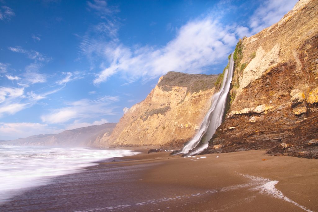
Alamere Falls Trail
- Distance from Sacramento: 111 miles (2.5 hours)
- Trail Length: 13.8 miles
- Elevation Gain: 1,955 feet
As one of Northern California’s most beloved hikes, Alamere Falls Trail is a lengthy but worthwhile seaside hike that ends at a stunning viewpoint of Alamere Falls crashing into the ocean from the top of a rocky bluff. The trail is well-marked and passes along the Pacific coastline, winding through several viewpoints of the surrounding hills and lakes. There’s an optional access point to the beach towards the end of the trail, but it can be quite slippery and steep – proceed at your own risk and with caution!
Island & Twin Lakes
- Distance from Sacramento: 88 miles (1 hour, 45 minutes)
- Trail Length: 6.2 miles
- Elevation Gain: 1,204 feet
If you’re looking to trade the dry, desert environment near Sacramento for cooler, more alpine scenery, head to the Island & Twin Lakes trail in the Desolation Wilderness. This moderate trail is one of the prettiest places on our list for hiking near Sacramento, with access to 3 glistening alpine lakes that reflect the stark rocky mountain peaks and emerald evergreen forests. Don’t be fooled, though - the trail has some tricky spots to navigate on the ascent, providing a good workout in addition to the picturesque views. Because of this trail’s popularity, we recommend getting there early in the morning to snag a parking spot (the lot is quite small), especially on weekends.

Difficult Hikes Near Sacramento
Rubicon Trail
- Distance from Sacramento: 102 miles (2 hours)
- Trail Length: 16.4 miles
- Elevation Gain: 2,306 feet
If you’re seeking a full day adventure somewhere beautiful, the Rubicon Trail is one of the South Lake Tahoe’s most popular and scenic trails. This alpine path winds through evergreen forests and above mountains, offering breathtaking views of the deep blue of Lake Tahoe below. It also passes by Eagle Falls, a stunning cascade that’s especially beautiful in the spring during the snowmelt season. Because it’s out-and-back, you can choose to do as much or as little of the trail as you’d like, although we’d recommend at least hiking out to the lakefront to catch those spellbinding views.
Note: This area is subject to seasonal road closures. Please visit here for more information. Additionally, there is a $10 fee to enter the park.
Granite Lake and Maggie’s Peaks
- Distance from Sacramento: 108 miles (2 hours)
- Trail Length: 4.1 miles
- Elevation Gain: 1,778 feet
Of all of the hikes in the Lake Tahoe area, the trail to Maggie’s Peaks is one of the local favorites. At just 4.1 miles, it’s a short hike distance-wise, but requires some serious elevation gain over a short length to get to the top. The views from the summit are outstanding, with panoramas of Tahoe’s Emerald Bay, Granite Lake, and some other smaller lakes and inlets nearby. While the ascent is quite steep and strenuous, locals say the views are absolutely worth the effort. If you’ve only got a short amount of time or want to get the most “bang for your buck,” the Maggie Peaks trail is definitely a winner.

Mount Diablo Summit Trail
- Distance from Sacramento: 92 miles (2 hours, 15 minutes)
- Trail Length: 7 miles
- Elevation Gain: 2,099 feet
One of the most famous and challenging hikes near Sacramento is the Mount Diablo Summit, located in its namesake Mount Diablo State Park. The trail quickly rises to show off abundant views of the mountains and hills below, and on clear days, you can see out for miles and miles. It seems like the mountains go on forever! It’s a pretty strenuous workout to get to the top, and the trail is quite exposed with very little shade or cover, so come prepared with a wide brimmed hat, sunglasses, and lots of sunscreen to protect yourself.
South Fork American River Trail
- Distance from Sacramento: 37 miles (45 minutes)
- Trail Length: 17.5 miles
- Elevation Gain: 2,798 feet
For those wanting extra long hikes near Sacramento, the South Fork American River Trail is an excellent full day hike or backpacking trip. At just 45 minutes from Sacramento, this trail is one of the closest difficult hike near the city. It’s an out-and-back trail that you can do as much or as little of as you’d like. Along the trail, there are a variety of scenes, from evergreen forests and river canyons to desert-like plains. The views from the higher altitudes of the trail are primarily of the surrounding mountains, offering a lovely stretch for photography or a picnic.

Yosemite National Park
- Distance from Sacramento: 141 miles (3 hours)
We couldn’t write a guide to hiking near Sacramento without at least mentioning Yosemite. This popular national park is famous for its hiking and climbing, and we couldn’t choose just one trail to mention here! Despite being around 3 hours from the city, it’s a VERY worthwhile trip for those who enjoy challenging hikes and backpacking adventures. If you have the time, we’d strongly recommend spending a weekend or more in Yosemite to enjoy several of the park’s hikes and beautiful scenery.
Note: There is an entrance fee to get into the park. There also may be limited services due to COVID-19. Visit here for more information.
Additional Resources for Hiking near Sacramento
What to Bring
- Breathable hiking clothes - For warmer hikes, you’ll want to wear a sweat-wicking shirt and breathable pants, like these Patagonia hiking shorts for men and women. For cold-weather hikes, we recommend dressing in layers, including merino wool baselayers for men and women, a down puffer jacket for men and women, and a Northface waterproof outer shell for men and women (a must for hiking in Seattle). And don’t forget a pair of the best women’s and men’s hiking socks!
- Trekking poles - You won’t need these for every single hike, but we suggest throwing them in your car just in case. We recommend the Black Diamond Trail Ergo cork trekking poles, which are lightweight, easy to transport, and durable.
- Water bottle - Having water available at all times is a huge must. To limit disposable plastic, we recommend bringing your own refillable water bottle. We’re obsessed with Hydro Flask water bottles because they keep water cold for hours.
- Sunscreen and bug spray - Sweatproof sunscreen and DEET bug spray can help you avoid sunburn and bug bites, two of hiking’s most annoying after-effects. Our favorite kind of sunscreen is Sun Bum, as it is free of harsh chemicals and safe for marine life, including coral reefs.
- A brimmed hat or cap - The sun can be brutal in open hikes, so always pack a brimmed hat or cap for day hikes in the sunshine.
- Emergency blanket and first aid kit - We’d strongly recommend bringing a first aid kit and a lightweight emergency blanket on every hike. Why? Because the unfathomable can happen, and it’s always best to play it safe.
- Durable day pack - A durable day pack is the perfect spot to stash all your hiking gear. While any backpack will do, we recommend the Osprey Tempest 20 or the Talon 22 day packs because they’re comfortable and breathable for long hikes. For more information, check out our best day packs for any terrain guide.
Wondering what exactly you should pack for your next hike? Visit our Complete Day Hiking Packing List for our full list and our top gear recommendations.

