Updated November 17, 2025
Charlotte, NC may not be known for being the most outdoorsy city in the US, but there are a surprising number of fantastic parks and trails nearby. With the Appalachian Mountains nearby and several forests, rocky peaks, and lakes to explore, Charlotte is a totally underrated city for outdoor activities. Hiking near Charlotte is a fantastic, affordable, and accessible way to explore all of the beautiful nature that the area has to offer. We created this guide to the best hikes near Charlotte to help you plan your next outdoor adventure!
Want more outdoor activities near Charlotte?

Easy Hikes Near Charlotte, NC
Little Sugar Creek Greenway
- Trail Length: 4.9 miles
- Location: South Charlotte (trailhead near Tyvola Road)
With paved, flat trails that run through some lovely green spaces, the Little Sugar Creek Greenway is a fantastic spot for hikers of all levels to take a nice, leisurely walk in the city. This multi-purpose trail running, biking, and hiking in Charlotte, NC is a local favorite, and is perfect for families or dog owners wanting a no-frills, easy walking path. Because it is an urban trail, don’t expect to feel like you’re out in the wilderness, but you will get to see some nice views of the creek and the surrounding forest along the trail.
Latta Nature Preserve Trail
- Trail Length: 5.4 miles
- Location: West of Huntersville, NC (~30 minutes north of Charlotte)
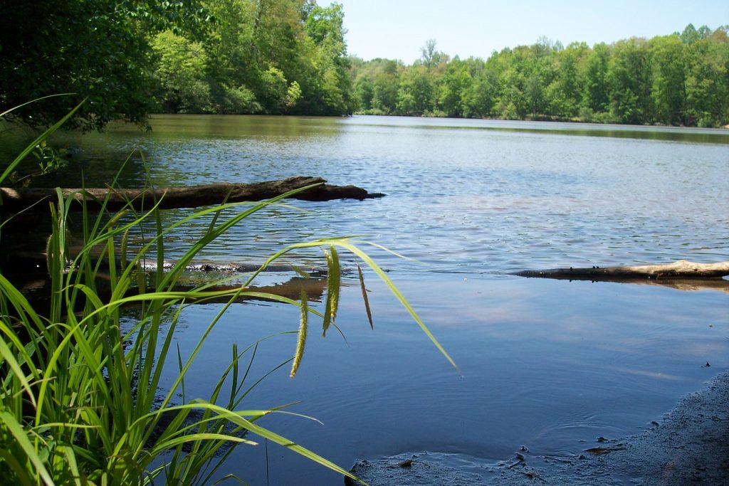
Located right next to the historic Latta Plantation, the Latta Nature Preserve Trail provides Charlotte hikers of all levels with a bit more immersion in nature than a typical city trail. It’s a great spot for hiking near Charlotte if you don’t want to travel too far but still want a nice, accessible trail through the forest. With its proximity to Mountain Island Lake, Latta Nature Preserve offers serene lake views along gravel paths that roll with gentle inclines and descents. Locals really enjoy this trail, but warn that it can get muddy after periods of rain. Check this website before you go for the latest trail status.

US National Whitewater Center
- Trail Length: Varies
- Location: Near Catawba Heights (western Charlotte)
While the US National Whitewater Center is best known for organizing whitewater rafting lessons, excursions, and competitions, there are a handful of lovely, easy hiking trails in the area as well. The trails here have a lot of variety, ranging from the powerful man-made river rapids to some more peaceful lakes and forests a bit farther out. The trails here are well-maintained and are largely accessible to families and beginners (though we’d recommend avoiding a visit right after heavy rains, as the trails can get very muddy).
Note: There is a $6 parking fee.
Reedy Creek Park and Nature Center
- Trail Length: 3.1 miles
- Location: Northeast Charlotte off of Grier Road
For a fantastic family-friendly hiking option, the Reedy Creek Park and Nature Center Trail is one of the best spots for hiking near Charlotte. This paved path is easy to navigate and brings hikers to some very beautiful scenery, including small creeks, a peaceful lake, and some old stone ruins. Because it’s located in a city park, there are also lots of recreational facilities, including picnic areas, sports fields, and more. Locals note that this is a really interesting trail, especially because of the rock house ruins you can explore, but that it can sometimes be hard to follow. You can download a map here to stay on track.
Greenway Bridges and Lake Loop
- Trail Length: 4.2 miles
- Location: Anne Springs Close Greenway
As one of the most spectacular easy hikes near Charlotte, the Greenway Bridges and Lake Loop is a beautiful blend of history and nature. Located in the Anne Springs Close Greenway, the trail is mostly flat and accessible to hikers of all levels. Along the 4.2 mile trail, you’ll pass under a large, historic bridge, cross narrow suspension bridges, and enjoy the thick forests and nature areas located in the park. If you’re a beginner and are only going to tackle one easy hike in Charlotte, we’d strongly recommend this one for the most varied and picturesque views.
Note: There is a $12 entry fee per person, and a $6 entry fee for youth (ages 5-12).
Moderate Hikes Near Charlotte
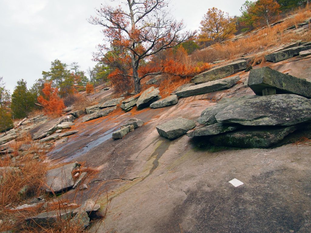
Stone Mountain Loop Trail
- Trail Length: 4.5 miles
- Location: Stone Mountain State Park
Looking for a bit more of a challenge and a mountain to summit? As one of the coolest and most unique hikes near Charlotte, Stone Mountain is a wonderful hiking challenge for all levels with some stunning rewards. The trails wind through the forest, across bridges and up stairs, with a finale at the rocky summit of Stone Mountain. With smooth rock faces that are striped with different shades of gray, the summit boasts breathtaking views of the cerulean Blue Ridge Mountains nearby!
Cove, Cedar Ridge, Creekside and Chestnut Trail
- Trail Length: 4 miles
- Location: McDowell Nature Center (~30 minutes southwest of Charlotte)
If you’re looking for a bit more peace and solitude than some of the more popular trails on our list, head to the McDowell Nature Center for a hike along the Cove, Cedar Ridge, Creekside, and Chestnut Trail. This moderate trail is mostly wooded, but also features a lake, a few bridges and boardwalks, and some eerie ancient tree stumps that have stories of their own. While this trail doesn’t have many sweeping views or rocky outcroppings, it’s common here to have the entire trail to yourself, making it a perfect escape from the city. For hiking near Charlotte without any stress, this trail is a great option.
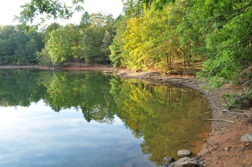
Lake Norman Lakeshore Trail
- Trail Length: 5 miles
- Location: Lake Norman State Park (~45 minutes north of Charlotte)
Water lovers will enjoy the 5-mile Lake Shore Trail in Lake Norman State Park, which spans the perimeter of a small peninsula. The jagged edges of the land near the water create a lot of variety along the lakefront, which offers stunning views of the forest reflecting into the still waters (especially in the fall!). While the trail can get popular in peak season, there’s a lot of space and small secluded areas to get your peace and quiet and enjoy the company of the lake and the surrounding trees.
Uwharrie Trail
- Trail Length: 8.4 miles
- Location: Uwharrie National Forest
The Uwharrie Trail is a 20-mile trail that stretches through the Uwharrie National Forest. While you have the option to hike the whole thing, you can also do just a section or two. If you do want to break down this long-distance trail into something more manageable, we’d recommend the section from Jumping Off Rock to Little Long Mountain, which is a moderately difficult trail that has plenty of campsites for backcountry trips. The trail is largely forested, and ends at the summit of Little Long Mountain, which has stunning views of the nearby mountain. You can even camp close to the summit to catch it at sunrise and watch the entire landscape glow in the morning light.
If you do choose to go for a longer hike on this trail, you’ll want to make sure you’re well-prepared. Check out our complete hiking packing list for all of the essentials you’ll need:
Fall Mountain Trail
- Trail Length: 3.8 miles
- Location: Morrow Mountain State Park
If you’re looking for a wonderful fall hiking trail with lots of photo opportunities, the Fall Mountain Trail at Morrow Mountain State Park is a great option. While there are lots of trails in the Morrow Mountain area, we like Fall Mountain the best for its variety, between mountain views, quiet forest paths, and picturesque sections. Locals love this trail for being extra quiet and peaceful, which is a great choice for weekends to let go of some of the stress of your daily city life.

Pinnacle Trail
- Trail Length: 4.2 miles
- Location: Crowders Mountain State Park
No list of hikes near Charlotte would be complete without an ode to the Pinnacle Trail, one of the most popular and scenic trails in the entire state. Boasting some of the best views of Crowder’s Mountain State Park, the summit of the Pinnacle consists of a rocky outcropping that’s beautiful in its own rite. The trail itself consists of a gradual incline to the top, so it’s great for hikers of all levels who are willing to take on the challenge! Those who do will be rewarded with one of the most iconic hiking views in the area.
NOTE: This is one of the most popular trails on our list, so go early if you want to avoid crowds along the way!
Difficult Hikes Near Charlotte
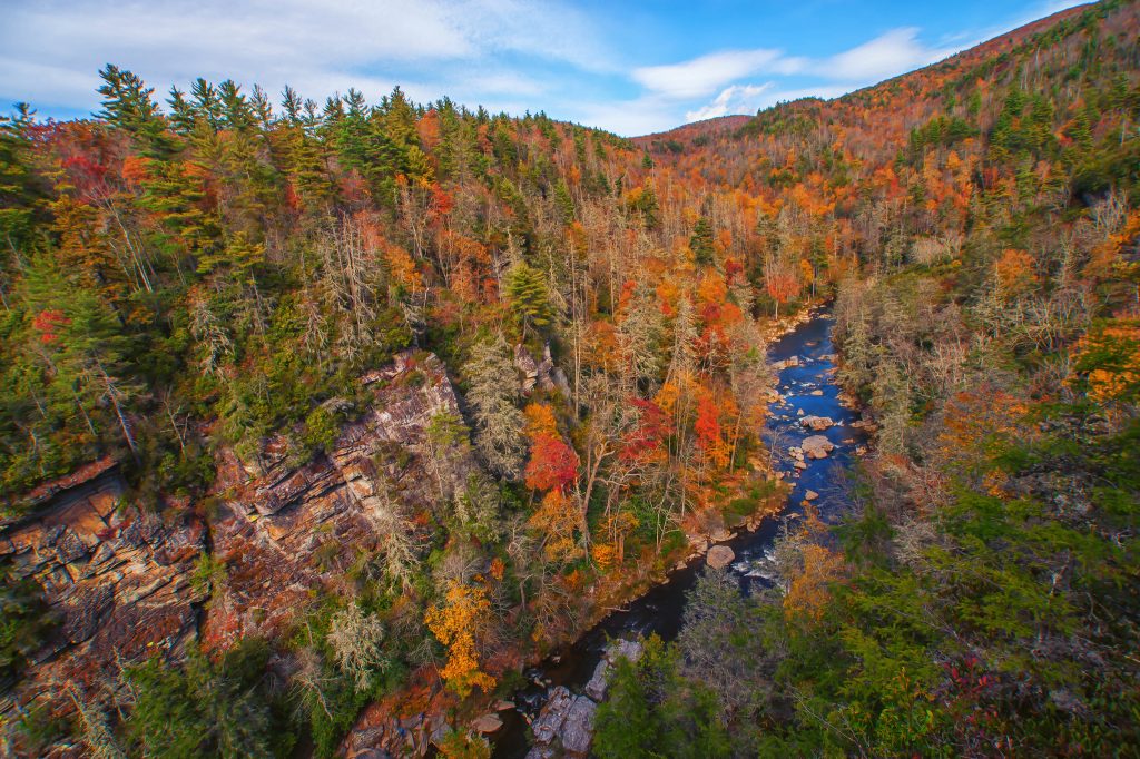
Linville Gorge Wilderness
- Trail Length: Varies
- Location: Linville Gorge Wilderness
Located near Asheville, the Linville Gorge Wilderness Area is a gorgeous place for hiking near Charlotte. There are several trails that weave throughout the region, but the two we’d recommend are Little Table Rock Trail (hard - 2.7 miles) and Hawksbill Mountain (moderate - 1.8 miles). We’d recommend both for experienced hikers, but if you’re looking for an extra challenge and workout, head to Little Table Rock Trail for some seriously steep inclines and rocky terrain. Because both hikes are so short, you could even do both in one day!
Ridgeline Trail
- Trail Length: 15.8 miles
- Location: Crowders Mountain and Kings Mountain State Parks
Have you ever wanted to do a hike that extended across two different states? The Ridgeline Trail is your chance! Spanning from Crowders Mountain State Park in North Carolina to Kings Mountain State Park in South Carolina, the Ridgeline Trail is one of the most beloved hikes near Charlotte for experienced hikers. The trails take you through forested areas and to some very spectacular views of Crowders Mountain and Kings Mountain. Locals state that this is hands down, one of the best challenging hikes in the state, and is definitely worth the challenge if you’re in the mood to work hard.

Chestnut Knob Trail
- Trail Length: 5.3 miles
- Location: South Mountains State Park
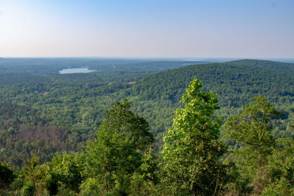
If it’s views of the tree-covered Blue Ridge Mountains you’re after, the Chestnut Knob Trail in South Mountains State Park is a great strenuous hike to tackle. Many of the viewpoints here offer uninterrupted views of the surrounding mountains and forests, which is rare given how many trees there are in North Carolina! You can also catch views along the way of High Shoals Falls, the park’s most well-known waterfall. This trail truly has a little bit of everything, and it is a wonderful option for experienced hikers wanting a rewarding yet challenging place to go hiking near Charlotte.
Vertical Mile Challenge to Hollow Rock Loop
- Trail Length: 3.6 miles
- Location: Rocky Face Mountain Recreational Area
Located just one hour from Charlotte, the Vertical Mile Challenge hike in Rocky Face Mountain Recreational Area is a solid, strenuous hike to get your blood flowing. While you can hike Hollow Rock Loop on its own, for experienced hikers, we recommend combining both hikes for an extra scenic and challenging adventure. For beautiful views and a hike that you can write home about, the Vertical Mile Challenge & Hollow Rock Loop trail is one of the best hikes near Charlotte.
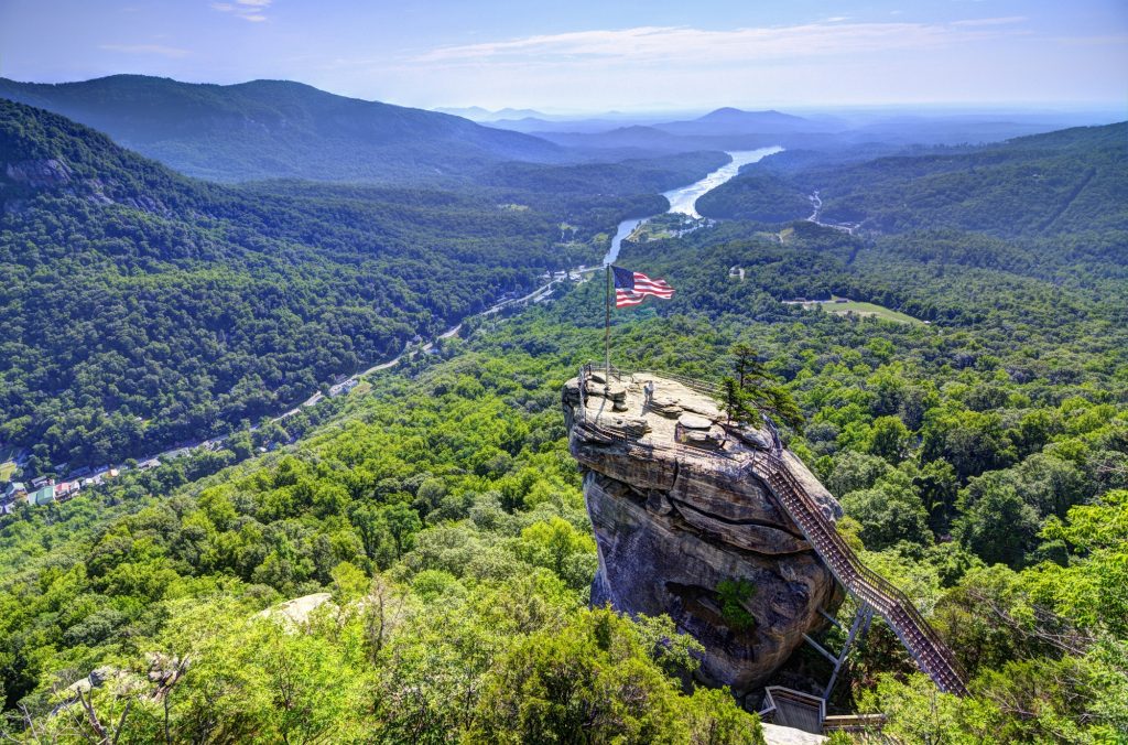
Chimney Rock State Park
- Trail Length: Varies
- Location: Chimney Rock State Park (Lake Lure, NC)
Chimney Rock State Park is one of the most well-known and iconic state parks in the area, and it is an awesome place to go hiking near Charlotte. While there are many different trails and paths you can hike, we’d recommend Party Rock and Exclamation Point for their spectacular views (great names, right?!).
Exclamation Point is a short, moderate hike (less than 1 mile) to a viewpoint where you can see fantastic views of Chimney Rock and the nearby valley. For hikers who want a more strenuous challenge, head to Party Rock (2.3 miles) for absolutely spectacular views of the valley and nearby lakes. Because they’re both short, you can tackle both in one day for an awesome half-day adventure.
Note: Visitors must buy tickets to enter the State Park. You can purchase tickets here.
Mount Mitchell
- Trail Length: 11.9 miles
- Location: Pisgah National Forest
Although it’s over 2.5 hours from Charlotte, we couldn’t resist including the Mount Mitchell trail on our list, which brings hikers up to the highest peak in the state of North Carolina. This trail is NOT for the faint of heart - it’s an 11.3 mile slog up steep, rocky terrain to reach the iconic summit. You’ll ascend a whopping 3,700 feet over just under 6 miles, which will really make you feel your legs! On the plus side, the incline is gradual, which means you won’t experience too much variation in steepness. At the top, you’ll be treated to the most jaw-dropping views in the state, and on clear days, you can see out many, many miles across the mountaintops. For the ultimate North Carolina bragging rights, hit up Mount Mitchell trail and be prepared for an adventure.

Additional Resources for Hiking Near Charlotte, NC
What to Pack
- Breathable hiking clothes - For warmer hikes, you’ll want to wear a sweat-wicking shirt and breathable pants, like these Patagonia hiking shorts for men and women. For cold-weather hikes, we recommend dressing in layers, including merino wool baselayers for men and women, a down puffer jacket for men and women, and a Northface waterproof outer shell for men and women (a must for hiking in Seattle). And don’t forget a pair of the best women’s and men’s hiking socks!
- Trekking poles - You won’t need these for every single hike, but we suggest throwing them in your car just in case. We recommend the Black Diamond Trail Ergo cork trekking poles, which are lightweight, easy to transport, and durable.
- Water bottle - Having water available at all times is a huge must. To limit disposable plastic, we recommend bringing your own refillable water bottle. We’re obsessed with Hydro Flask water bottles because they keep water cold for hours.
- Sunscreen and bug spray - Sweatproof sunscreen and DEET bug spray can help you avoid sunburn and bug bites, two of hiking’s most annoying after-effects. Our favorite kind of sunscreen is Sun Bum, as it is free of harsh chemicals and safe for marine life, including coral reefs.
- A brimmed hat or cap - The sun can be brutal in open hikes, so always pack a brimmed hat or cap for day hikes in the sunshine.
- Emergency blanket and first aid kit - We’d strongly recommend bringing a first aid kit and a lightweight emergency blanket on every hike. Why? Because the unfathomable can happen, and it’s always best to play it safe.
- Durable day pack - A durable day pack is the perfect spot to stash all your hiking gear. While any backpack will do, we recommend the Osprey Tempest 20 or the Talon 22 day packs because they’re comfortable and breathable for long hikes. For more information, check out our best day packs for any terrain guide.
Wondering what exactly you should pack for your next hike? Visit our Complete Day Hiking Packing List for our full list and our top gear recommendations.


