Updated October 22, 2025
While New England typically isn’t immediately associated with hiking or outdoor adventures, there’s a ton to do in the area once you start looking for it. Between the beautiful White Mountains to the rocky shorelines, stunning waterfalls and challenging terrain await. Hiking in New England is heinously underrated, and there are tons of trails in the region that range from easy nature walks to difficult traverses. We created this guide to the best hikes in New England so you can start to plan your next weekend adventure!

15 Best Hikes in New England for Adventurous People
Moxie Falls
- Location: West Forks, ME
- Trail Length: 1.7 miles
- Elevation Gain: 226 feet
- Difficulty: Easy
One of the coolest easy hikes in New England is to Moxie Falls, one of the state’s highest waterfall cascades with a 90-foot vertical drop. Not only is this trail accessible to all levels of hikers, but it’s extremely picturesque, featuring dozens of short waterfalls along the Moxie Stream leading up to the big cascade at the end of the trail.
If you’re feeling up for swimming, you can take the stairs to the bottom of the falls where there’s a swimming area. It can get really crowded on the weekends, so we’d recommend going during the week or early in the day if you want to avoid the crowds.

Artist Bluff & Bald Mountain
- Location: Franconia Notch State Park (Franconia, NH)
- Trail Length: 1.5 miles
- Elevation Gain: 436 feet
- Difficulty: Easy/Moderate
Hailed as one of the most beautiful views in the White Mountains, Artist Bluff sits on the edge of Bald Mountain and is accessible on a moderate hike. For the views alone, paired with a relatively easy, short trail, this is definitely one of the best hikes in New England. While the trail is only 1.5 miles, it really packs a punch in terms of rocky uphills, pretty forest areas, and of course, rocky outcroppings that offer stunning views of the surrounding mountains and nearby Echo Lake. This is an extremely popular hike, so we’d recommend getting here early in the morning or avoiding weekends, especially during the fall when the views are especially magical.
Read More: How to Hike the Artist Bluff Loop in Franconia Notch State Park
Cliff Walk
- Location: Newport, RI
- Trail Length: 6.6 miles
- Elevation Gain: 324 feet
- Difficulty: Moderate
Arguably the most quintessential and beloved hiking trail in all of Rhode Island is the Cliff Walk, a nearly 7-mile trail bordering the ocean near Newport. This trail is unique from the others on the list because it’s partially paved and partially rugged, meaning there’s truly something for every hiker here. No trip to Newport would be complete without doing at least a small part of this trail!
To one side of the trail is the ocean, with waves that crash against the cliffs below, and to the other side are some of the most magnificent, grandiose mansions in the East Coast. Some are privately owned, some are new historic sites, schools, and museums, and a few are even open to stay in as bed & breakfast type establishments. One thing is for sure, though – these elegant homes are a huge part of the view of this trail. It’s fun to look at them and dream about what their stories are as you’re hiking!

Bash Bish Falls
- Location: Bash Bish Falls State Park (South Egremont, MA)
- Trail Length: 2.1 miles
- Elevation Gain: 521 feet
Located on the border with New York, Bash Bish Falls is a wonderful (and dearly beloved!) place for hiking in Massachusetts. This 2.1-mile trail leads through a forested path to a scenic set of two waterfalls, which is a very popular spot for photography in the state. You’ll cross the MA/NY border and enjoy some pretty creek views along the way, and the falls at the end drop nearly 60 feet, which is a spectacular sight.
Because of the short length and variety of sights on the trail, it’s an especially popular choice for families with young children. Because this trail is so easy and accessible to all experience levels, it can get extremely crowded during summer and fall weekends. Head there early or on weekdays for the best experience!
Hamilton Falls
- Location: Ball Mountain State Recreation Area, VT
- Trail Length: 5.8 miles
- Elevation Gain: 757 feet
- Difficulty: Moderate
If you’re looking for a beautiful waterfall hike that offers a little bit of challenge, look no further than Hamilton Falls. Located in Ball Mountain State Recreation Area, this hike combines the beauty of Vermont’s forest areas and some pretty unique rock formations, all with a lovely, picturesque waterfall at the end of the trail.
The beginning of the trail is easy and relaxed, and the last mile up to the falls gets a little more challenging in terms of ascent. However, the hard work is worth it when you arrive at Hamilton Falls and get to soak in the beautiful scenery and beauty of its surroundings. The waterfall itself is situated on a diagonal rock slab and it looks really unique from other cascades in the area.
Bear Mountain
- Location: Salisbury, CT
- Trail Length: 6.5 miles
- Elevation Gain: 1,702 feet
- Difficulty: Moderate
Located in the Berkshire Mountains, Bear Mountain is a moderate summit trail that takes you to a scenic peak. As part of the Appalachian Trail, this path is one of the more frequented, longer hikes in New England, and for good reason – the rocks on the top of the mountain offer lovely views of the surrounding mountains, especially in the fall when these tree-covered peaks begin to change colors.
Bear Mountain is situated in the area surrounding Salisbury, CT, which is one of the more topographically challenging areas for hiking in Connecticut. Here, you can find hikes of moderate and even strenuous difficulty that even the most experienced hikers will enjoy. If you’re looking to do a hiking weekend getaway, this is a fantastic area to visit!
Sleeping Giant Head Trail (Blue and Violet Loop)
- Location: Sleeping Giant State Park
- Trail Length: 8 miles
- Elevation Gain: 1,692 feet
- Difficulty: Strenuous
Perhaps the coolest and most challenging trail on our list, the Sleeping Giant Head Trail is one to remember. You’ll scramble up scenic (but challenging!) rock formations over the course of nearly 1,700 feet of elevation gain to reach the summit of this mountain in the scenic Sleeping Giant State Park. Aside from having the coolest name ever, this park boasts absolutely breathtaking views of southwestern Connecticut, especially in the fall when the leaves change. What avid hikers like the most about this trail is that it’s a really good workout, with several scrambling areas and a very steep, leg burning uphill that makes the views at the top even more rewarding.
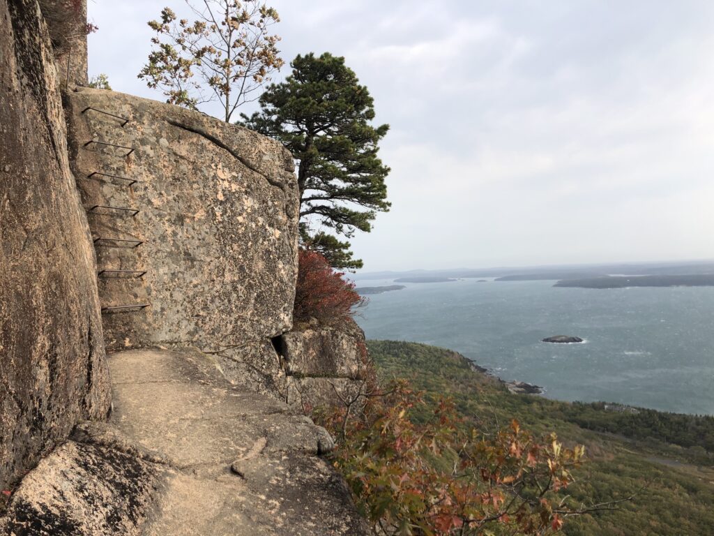
Precipice & Beehive Trails
- Location: Acadia National Park (Bar Harbor, ME)
- Trail Length: 1.4 miles
- Elevation Gain: 488 feet
- Difficulty: Moderate/Difficult
As one of the most popular hikes in New England, the Beehive and Precipice trails are located in the Sand Beach area of Acadia National Park and offer spectacular shoreline and mountain views. However, these hikes are tricky (and famous) for jagged, rocky climbs and ladder rungs that help hikers climb nearly 500 feet up the side of a cliff. Yes, you’ll be using your hands and feet on these trails, so we’d only recommend doing the Beehive and/or Precipice on dry, sunny days when the rocks aren’t slippery or wet.
If you’re willing to practice safety and work hard, the trail itself can be really fun and thrilling, and the views from the top of Acadia’s coastline are absolutely amazing. Throughout this rocky cliffside climb, you’ll find rock “staircases,” metal ladders and rungs, and good old fashioned scrambling. Not for the faint of heart! At the top, you’ll see epic views of the nearby islands in Bar Harbor, Sand Beach, Thunder Hole, the surrounding mountains and lakes, and the ocean.
Read More: Everything You Need to Know Before Hiking the Beehive Trail
Read More: Everything You Need to Know to Hike the Precipice Trail
NOTE: The Beehive & Precipice trails are only for experienced hikers and should be done with extreme caution. Several people have fallen and died on these trails, so do not take them lightly. No dogs allowed here and it’s definitely not advised to bring young children either.
Franconia Ridge Loop
- Location: White Mountain National Forest
- Trail Length: 8.6 miles
- Elevation Gain: 3,822 feet
- Difficulty: Strenuous
If you’re going to do any hike in the White Mountains, Franconia Ridge is it. As one of the most difficult and spectacular day hikes in New England, this trail takes you to the peak of 3 of the state’s mountains and offers arguably the best views in the entire White Mountain National Forest. This trail isn’t for the faint of heart, though – there are several areas with extremely steep grades, rocky traverses, and windy ridge lines that require ample experience and grit to push through. For those willing to take on the challenge, however, Franconia Ridge is a fantastic day-long hike you’ll certainly never forget.
Camel’s Hump
- Location: Camel’s Hump State Park
- Trail Length: 6 miles
- Elevation Gain: 2,578 feet
- Difficulty: Strenuous
If you’re going to do any strenuous hikes in New England, we’d recommend the Camel’s Hump Trail in Vermont. This summit hike is a popular one located in its namesake state park, and it’s definitely not for the faint of heart. The first few miles of the trail are moderate, with a fairly gradual incline. However, when you reach the rocky sections, it gets much steeper and more intense, with some scrambling incolved. At the top, you’ll get extraordinary views from the third highest peak in Vermont – an incredibly special and unique experience that some would argue is the best hike in the state.

Mount Williams, Mount Fitch, Mount Greylock, and Stony Ledge
- Location: Mount Greylock State Reservation (Williamstown, MA)
- Trail Length: 12.4 miles
- Elevation Gain: 3,015 feet
- Difficulty: Strenuous
If one western Massachusetts summit isn’t enough for you, there’s a trail that takes you to four. The Mount Williams, Mount Fitch, Mount Greylock, and Stony Ledge trail hits 4 mountain peaks over the course of 12.4 miles, making for a spectacular full-day hike that even experienced hikers will truly enjoy. Many people are able to finish this trail in around 7 hours, including stops for views and rest at each summit. For hikers who are looking for a challenging and highly rewarding hike through some of the state’s tallest mountains, this trail is definitely for you. Hikers and backpackers looking for a fun challenge will find that this is one of the best hikes in New England for a full day of adventure.

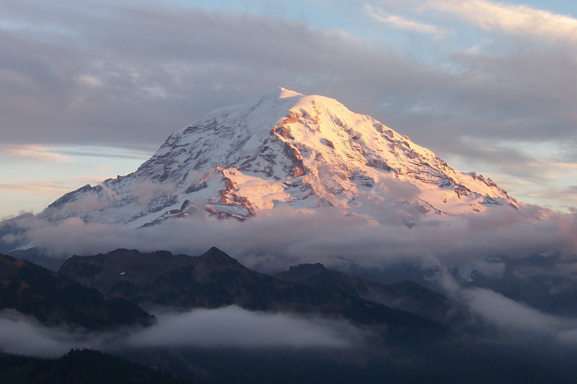
Mount Washington
- Location: White Mountain National Forest
- Trail Length: 7.9 miles
- Elevation Gain: 4,169 feet
- Difficulty: Strenuous
Topping off at 6,288 feet of elevation, Mount Washington is the highest mountain in the Northeast and is one of the most famous in the country for its dangerous traverses and unpredictable weather. Summiting this mountain by foot is a rite of passage for many New England hikers, and is something that requires lots of preparation and training. While the top is accessible by car and train, hiking up offers some of the most exhilarating and spectacular views that the White Mountains have to offer. It’s one of the most iconic places for hiking in New Hampshire, and definitely a bucket list-worthy adventure.
Despite its relatively short elevation compared to its western counterparts, Mount Washington is infamous for its many hiker deaths and rescues over the years and has earned its reputation as the “most dangerous small mountain in the world.” Yup, that means that hiking up this mountain is only suitable for extremely experienced and physically fit hikers who know how to scramble and hike through potentially temperamental weather conditions.
Mount Mansfield
- Location: Underhill State Park
- Trail Length: 7.3 miles
- Elevation Gain: 2,880 feet
- Difficulty: Strenuous
For experienced hikers, one of the most quintessential hikes in New England is the Mount Mansfield Loop trail, which brings you from the base of the mountain to the tallest peak in Vermont, all in one challenging, 7.3-mile trail. You’ll ascend 2,880 feet in just over 3.5 miles, traversing rocky areas, scrambles, and rock crevasses that will get your heart pumping.
At the summit, you’ll catch panoramic views of Underhill State Park, Smugglers’ Notch State Park, and many of the ski resorts in the area. You’ll also be standing at the highest point in the state of Vermont, at 4,393 feet of elevation.

Mount Katahdin & Knife Edge
- Location: Baxter State Park (Millinocket, ME)
- Trail Length: 8.1 miles
- Elevation Gain: 3,897 ft
- Difficulty: Strenuous
One of the most famous (and most challenging) hikes in New England is Maine’s Mount Katahdin, the highest peak in the state, with an elevation of 5,269 feet. Even more (in)famous than the summit, however, is the ridgeline, which is informally known as Knife’s Edge. This stark, rocky ridge has dropoffs on both sides, making it a dangerous and thrilling hiking area that’s only suitable for experienced hikers. While the hike is strenuous and typically takes an entire day, the views of northern Maine from the summit and surrounding ridges are out of this world, and undeniably some of the most jaw-dropping panoramas in the state.
The 8.1-mile hike to the summit of Mount Katahdin should only be attempted by experienced, seasoned hikers who know how to hike at high altitudes and in unfavorable (windy and potentially rainy) conditions. It also requires quite a bit of scrambling and stamina. You should only attempt this hike on clear days, as it can be extremely dangerous in bad weather.
Additional Resources for Hiking in New England
What to Bring
- Hiking boots - You can’t hike without appropriate footwear, period. For most trails, we recommend an all-purpose waterproof boot with ankle support. We recommend Salomon hiking boots or Keen hiking boots for a comfortable hike.
- Breathable hiking clothes - For warmer hikes, you’ll want to stay cool in a sweat-wicking shirt/tank top and breathable pants, like these PrAna hiking pants for men and women. For cold-weather hikes, we recommend dressing in layers, including merino wool baselayers, an insulated puffer jacket, and a waterproof outer shell. And don’t forget a pair of the best hiking socks in the world!
- Trekking poles - You won’t need these for every single hike, but we recommend throwing them in your car anyway just in case. We recommend the Black Diamond foldable trekking poles, which are lightweight and easy to transport.
- Water bottle - Having water available at all times is a huge must. To spare disposable plastic, we recommend bringing your own refillable water bottle. We’re obsessed with Hydro Flask bottles because they keep water cold for hours, but a good old Nalgene works very well too.
- Sunscreen and bug spray - This should be self-explanatory, but sweatproof sunscreen and DEET bug spray can help you avoid sunburn and bug bites, two of hiking’s most annoying after-effects.
- A brimmed hat or cap - The sun can be brutal in open hikes, so always pack a brimmed hat or cap for day hikes in the sunshine.
- Emergency blanket and first aid kit - We’d strongly recommend bringing a first aid kit and a lightweight emergency blanket on every hike. Why? Because the unfathomable can happen, and it’s always best to play it safe.
- Durable day pack - A durable day pack is the perfect spot to stash all your hiking gear. While any backpack will do, we recommend Osprey day packs because they’re comfortable and breathable for long hikes.
Wondering what exactly you should pack for your next hike? Visit our Complete Day Hiking Packing List for our full list and our top gear recommendations.
Related Articles
- 15 Stunning Hikes in Maine That You Absolutely Cannot Miss
- 17 Jaw-Dropping Hikes in New Hampshire for All Levels
- 15 Gorgeous Hikes in Vermont You Need to Try ASAP
- 12 Incredible Hikes in Connecticut for All Levels
- 14 Awesome Hikes in Rhode Island for All Levels
- 15 Spectacular Hikes in Massachusetts for Every Kind of Hiker
