Updated June 29, 2025
Located just minutes from New York City, the Hudson Valley is a popular weekend spot for New Yorkers looking for an escape from the bustle of the city. A lot of the most popular hikes near NYC are located here, with plenty of rolling hills and mountains offering spectacular views of the river and beyond. Many of these trails are even accessible without a car! If you’re looking for a great way to get outdoors without straying too far from the city, check out these gorgeous Hudson Valley hikes, specifically curated by Alex Bellink, an outdoorsy Hudson Valley local.
Best Hudson Valley Hikes for All Levels
Anthony’s Nose
- Trail Length: 1.9 miles
- Elevation Gain: 675 feet
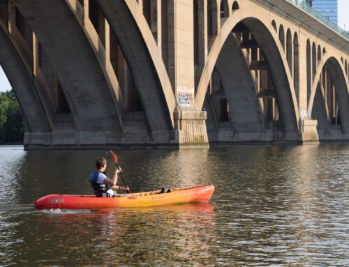
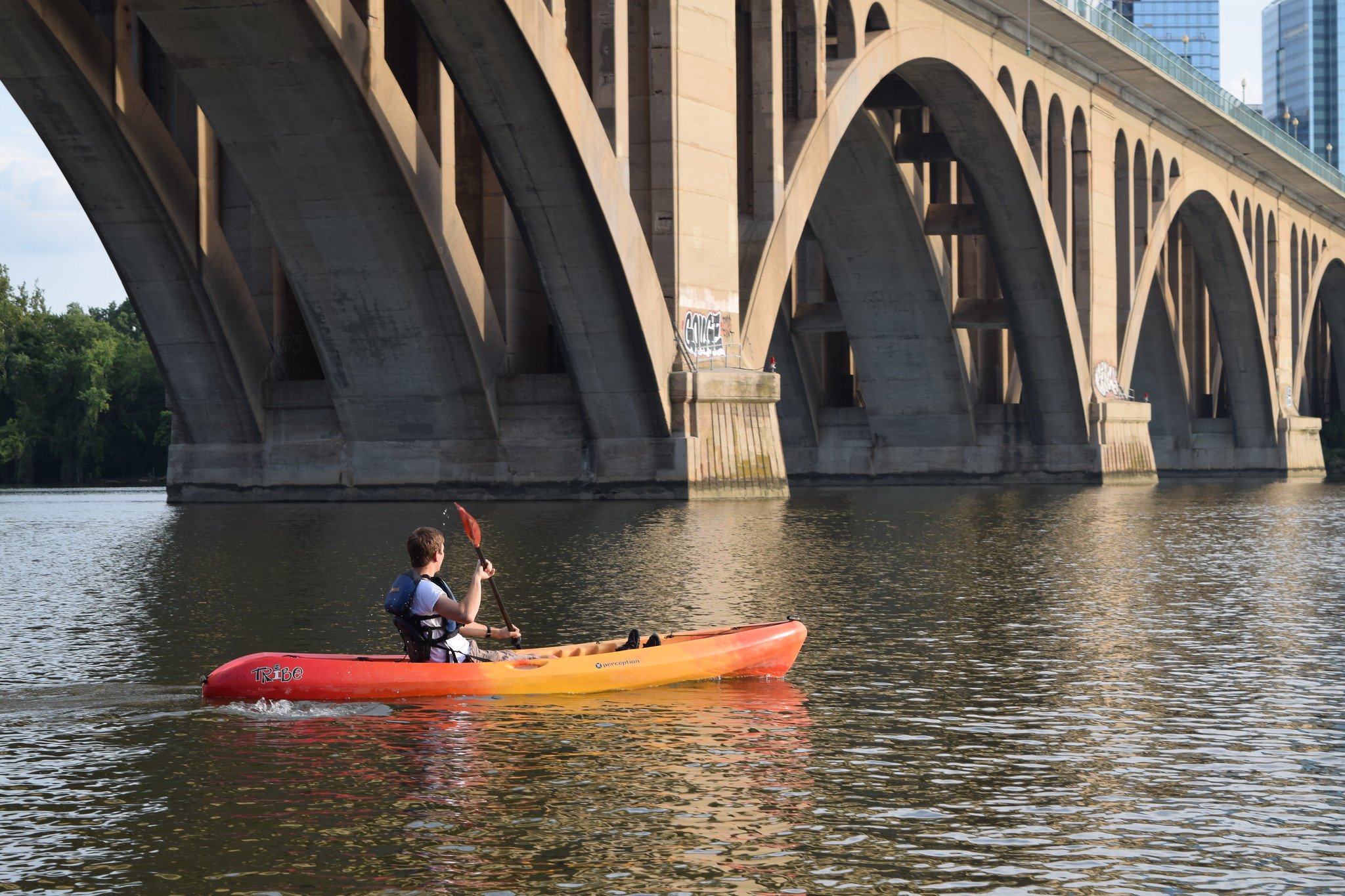
This steep, but relatively short climb is one of the more popular Hudson Valley hikes, one of the most scenic in Westchester County. It’s a perfect day trip if you’re coming from the city or live in the lower Hudson Valley and don’t want to drive too far. It begins with a strenuous climb for the first half mile, but then flattens out and rewards you with sweeping views of the Hudson River and the Bear Mountain Bridge directly below.
How to get there: Take the train to the Peekskill Metro North and then a 10 minute taxi or Uber ride to the trail head. There is limited parking next to the trail head itself, and 9D is too narrow to park off of, so go early or on a weekday if possible.
Sky Top Trail at Mohonk Preserve
- Trail Length: 1.6 + 2.2 miles from the parking lot
- Elevation Gain: 295 feet
Mohonk Preserve is situated right in the heart of the Shawangunk Mountains between the Catskills and the Hudson Valley and is known as one of the most beloved preserves. Although there are over 40 miles worth of trails, the Sky Top Trail is one of the classic Hudson Valley hikes which winds up from the the very unique Mohonk Mountain House, a castle like hotel perched above Mohonk Lake.
From the top of this easy 1.6 mile hike you’ll be rewarded with views of the hotel, lake, and surrounding mountains of the Shawangunk Ridge which are particularly stunning in the fall when the colors of the leaves are popping.
How to get there: Without a reservation to the hotel, you will have to pay an entrance fee to the park which is $29. Do note that public parking is located 2.2 miles before the trail head at the Mohonk Gatehouse, so allot for enough time to walk this road.
Bear Mountain / Perkins Fire Tower
- Trail Length: 3.8 miles
- Elevation Gain: 1,154 feet
One of the most iconic places for hiking in the Hudson Valley is Bear Mountain. At the crossroads of the Appalachian Trail, the Hudson River, and Harriman State Park, it is a hiker’s paradise! Begin at the Bear Mountain Inn where there is a massive parking lot and head to the the right of the inn, past the lake to take the stairs up. As you climb up the stairs, which turns into a path, you may pass some wet spots, especially if it has rained recently, so be sure to wear waterproof hiking boots.
Continue until you reach the Perkins Memorial Tower which is open to the public for 360 degree views of the surrounding area. You’ll even find some history of the region inside the tower as you climb up. Continue on the trail for the full loop toward the Overlook Lodge on the east side of the mountain, or take the stairs back down to the the parking lot if you’re running low on time.
How to get there: Take the train to the Peekskill Metro North and then a 20 minute taxi or Uber ride to the Bear Mountain Inn Parking Lot. If driving, take the Palisades Parkway North to the Bear Mountain Bridge. Right before the bridge, at the traffic circle, take the 1st exit onto US-202 W/Rte 9W S and the entrance to the park will be on your right.
Tivoli Bays
- Trail Length: 3 miles
- Elevation Gain: minimal
This series of trails in Dutchess County right along the Hudson River Estuary is perfect if you’re looking for a place to take your daily run or for one of the easier Hudson Valley hikes on flatlands that has great scenery. Along the way you can even walk through an abandoned building, which is fun for a photoshoots. For the bird lovers, you’ll find a great deal of wildlife nesting along the banks of the river. Great to bring your dog on these trails, but be mindful that it can get extra muddy, especially in the winter and rainy season!
How to get there: Turn left on Kidd Lane, if coming south from 9G. About a half mile down you will see a parking area for Tivoli Bays Wildlife Management area on Access Rd to the left.
Teatown Lake Reservation
- Trail Length: 3.8 miles
- Elevation Gain: 387 feet
The Teatown Lake Reserve is run by a non-profit organization which has created 15 miles of trails around the Teatown Lake, a nature center, and even an island with 230 types of flowers. There are multiple trails to take from the main parking lot, but we recommend the Three Laker Loop which passes by three lake, as the name implies and has a surprising sweeping view of the Hudson Valley without a significant elevation gain.
Follow the signs from Visitor Center to the orange “TL” trail marker for an easy hike through the woods. It will take you on a loop past Vernay Lake, Shadow Lake, underneath power gigantic power lines, and after about an hour if you walk at a casual pace, back around Teatown Lake. After crossing Teatown Road take a right onto the blue Lakeside Loop (labeled “LS”) onto the boardwalk that goes right over the lake.
How to get there: If coming from the Taconic State Parkway, take a right on Spring Valley Road and then a left at the fork. You will see the nature center on the right, shortly after where there is a large parking lot. Parking does cost $5, but it goes right back to maintaining the trails. Cross the street in order to begin the hike where the trail map is posted.
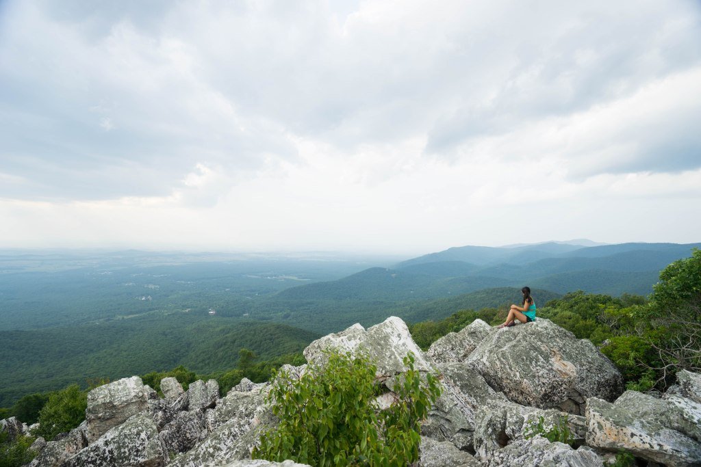
Overlook Mountain
- Trail Length: 4.6 miles
- Elevation Gain: 1,397 feet
For a good, hardy hike at the edge of the Catskills, Overlook Mountain is one of the best Hudson Valley hikes to tackle if you’re headed to the Woodstock and Saugerties area. The layer of fog which is commonly found early in the morning surprisingly makes for a brilliant on this Ulster County hike!
A strenuous 4.6 mile hike with a steep incline, you’ll be treated at the top with the fire tower, although it is reportedly closed as of October 2020 due to renovations. Continue on to visit the old Mountain House Hotel Ruins, as featured in Atlas Obscura for a real treat plus magnificent views of the Catskills Mountains.
Stissing Fire Tower
- Trail Length: 1.8 miles
- Elevation Gain: 900 feet
The hike to this fire tower in Dutchess County is far enough from the Hudson River that it’s a bit off the beaten track. If you’re looking for a moderately difficult, but short hike that is not so busy, this is it! There are two paths up, a shorter, but steep way and a more gradual trail that is a bit longer. It should take you about 45 minutes to an hour to climb the rocky Orange Trail to the top, where you can then climb up the rickety Stissing Fire Tower. Views from the top are remarkable and you may even see the Hudson on a clear day.
How to get there: Park on the side of Lake Road on the right side. There will be two trails to go up: the orange loop and blue trail. We recommend taking the orange trail up and the blue down, as it’s less steep.
Peekamoose and Table Mountain Trails
- Trail Length: 10 miles
- Elevation Gain: 2,368 feet
If you are looking for one of the more challenging, longer Hudson Valley hikes, the Peekamoose and Table Mountain Trails will bring you to the summit of two mountains around 3,840 feet. Located about 50 miles west of Kingston, these trails create the ultimate in and out tour of the region traversing bridges, creeks, going up and down, presenting stunning views of New York’s Catskill region. If you’re thinking about sleeping under the stars, there are even some opportunities to camp off of the Denning Road trailhead.
Getting there: Parking in addition to camping can be found at the end of Denning Road.
Kaaterskill Falls
- Trail Length: Normally 2.6 miles, with current parking situation as of October 2020, under 1 mile.
- Elevation Gain: 787 feet
This easy trail leads you to one of the most beloved waterfalls of the Hudson Valley, Kaaterskills Falls, which were made popular when mentioned by Washington Irving in his 1819 short story, “Rip Van Winkle”. Marvel at the majestic double tiered falls that combined are 260 feet, making it one of the largest drops in New York State from the top viewing deck before walking down about 100 stone steps to the lower falls.
In the summer time you can take a dip in the pools below the falls and cool off, but it’s just as scenic in the winter with the snow surrounding this magical scene in the Catskills. Be aware that the rocks can get slippery, so take caution and stay on the marked path to enjoy the falls to it’s fullest extent!
Getting there: At the moment the main trailhead parking is closed. It is recommended to go straight to the parking lot at the end of Laurel House Road, off of Route 18 or North Lake Road. This will make the walk much shorter from the current parking lot.
Rockwood Hall
- Trail Length: 1.8 miles
- Elevation Gain: Minimal/900 feet, depending on which access point you choose
Rockwood Hall, located in Sleepy Hollow is a popular, heavily trafficked trail, but for good reason! The wide path that is partly gravel, is easily accessible and traverses through fields, woods, and right above the train tracks that border the Hudson River. Head out around golden hour for a magnificent sunset view over the Hudson River at the top where you can see as far south to the Manhattan skyline and the George Washington Bridge.
How to get there: There are two access points to the trails, both with parking on the side of the road. One option is to turn down on Rockwood Road and park to the right, before the gate for the Regeneron Pharmaceutical Offices. The second option is to turn onto Phelps Way toward the hospital. Immediately after the first intersection (with Hospital Access Rd) to your left is a small parking lot. Park here and cross at the cross walk to the trails.
How to get there: There is a parking lot with a brown sign labeled “Overlook Mountain Wild Forest Trail Head Parking” on the right side of Macdaniel Road/Meads Mountain Road, if coming from Woodstock to the south.
Pine Meadow Trail at Harriman State Park
- Trail Length: 4-10 miles
- Elevation Gain: 1,171 feet
Pine Meadow Trail leads to one of the many lakes in Harriman State Park. It’s one of the Hudson Valley hikes that takes you to a waterway you can legally swim in. Although it may be too cold to swim during many times of the year, the hike is still worth doing for the view. Beginning with a strenuous 500 foot elevation gain for the first quarter of the hike, it then levels out, with some smaller inclines for a pleasant walk along a rocky path and along a brook. Keep an eye out for snakes on this moderately difficult trail, as they are known to slither on by!
When the weather is warmer, enjoy a refreshing dip in Pine Meadow Lake at the top. Follow the full loop up to Catamount and Ramapo Mountains 10 miles or just head 4 miles into the lake if you’re looking for a shorter hike.
How to get there: Be aware that there are strict regulations against parking at the Equestrian Center, which is the closest lot to the trailhead. As of 2020, you have to find a spot on the street or in the neighborhoods near by and walk a bit to the trailhead, which may take some extra time.
Western Ridge Trail Loop at Schunemunk Mountain State Park
- Trail Length: 7.4 miles
- Elevation Gain: 1,679 feet
As a formerly hidden gem in Orange County, the west side of the river has been gaining traction (no pun intended) in recent years as one of the best hiking areas within an hour of NYC. Here you can find not just woods, but meadows, open fields, and most exciting: a 193 foot high train trestle spanning 3,200 feet across a grassy valley, which is allegedly the longest train trestle east of the Mississippi. Although it’s illegal to climb onto it, you can walk underneath it before beginning the 7.4 moderate loop up to Schunemunk Mountain itself.
How to get there: Parking is limited in the lot on Ottercreek Road, and there have been issues of overcrowding and illegally parked cars on the road being towed out, so it’s suggested to go early or on a weekday if possible.
Twin Mountain Summit
- Trail Length: 5.9 miles
- Elevation Gain: 3632
This moderately difficult hike in the Indian Head Wilderness will get your blood flowing and take you through lush pine covered forest and through fields of wild flowers, up to some of the best views in Greene County. You’ll have to follow two different trails, first the Devil’s Path which will include some rock scrambling, and then you’ll hook up into the Jimmy Dolan Notch, in order to reach the summit at 3,632 feet above sea level.
When you arrive at the first overlook, Twin Mountain South, take a break and enjoy the view of the glorious Catskill Mountains. We think that this view is even better than the final summit!
How to get there: Turn on Prediger Road from Route 16 (Platte Cove Road), and at the end of the road, there will be a parking lot right at the trail head.
Bash Bish Falls Trail
- Trail Length: 2.1 miles
- Elevation Gain: minimal
Bash Bish Falls is one of our favorite waterfalls near New York City. Although it’s technically one of the Hudson Valley hikes, half of the park lays in Massachusetts in the Taconic Mountains at the edge of the Berkshires. This easy 2.1 mile hike along the crystal clear Bash Bish Brook will lead you to the 200 foot high Bash Bish Falls.
In the summer you can swim, but it’s just as scenic to wander down the trail to the gushing falls in the spring and autumn when they are full from the rain. It can get busy on weekdays and later in the day, so it’s best to start early!
How to get there: Note that the parking lot on the Massachusetts side is NOT open as of October 2020. Make sure to park in the New York lot which is right off of Route 344.
Bull Hill at Hudson Highlands
- Trail Length: 4.3 miles
- Elevation Gain: 1,131 feet
This is part of the Hudson Highlands Trail System which runs along the edge of the river in Putnam County. You’ll pass through the ruins of the Cornish Estate also known as “Northgate”, a series of stone homes that were built by a NYC diamond merchant in the 1910s.
There are two options for this trail: the full loop which is meant to take about 4-5 hours (5.5 miles) or the short loop, 2-3 hours and 4.3 miles. Either way, you will be rewarded with sweeping views of the Hudson River and Storm King Mountain on the west side of the river. If you’re feeling adventurous you can even connect to the famous Breakneck Ridge Trail.
How to get there: There is a small parking lot with limited spots at Little Stony Point on the west side of 9D. The trail starts across the road on the east side. Otherwise, you’ll have to find parking off the side of 9D.
Old Croton Aqueduct Dam Trail
- Trail Length: 1.6 miles
- Elevation Gain: 196 feet
The Old Croton Aqueduct Dam trail at the New Croton Dam is one of our favorite easy, but scenic walks in Westchester County. The dam, which was completed in 1906, is one of the most unique structures we’ve seen on any of the Hudson Valley hikes, with its tiered, stone waterfalls on the west side of the dam. Bring your dog (or adventure cat!) along for a nice 1.6 mile loop which traverses the top of the dam itself.
When you get to the top you’ll gaze out upon the Croton Reservoir, one of New York City’s water suppliers. Be cautioned that if you do the full loop you will be walking on the side of the highway to get back to the parking lot. If you don’t feel comfortable with ‘ this, it may be better to walk back down the way you came.
Getting there: Plenty of parking is available in the lot at the New Croton Park right off of Route 129, not far off of the Taconic State Parkway.
Sugarloaf Hill Trail
- Trail Length: 2.9 miles
- Elevation Gain: 656 feet
If you live in New York City and are looking for some Hudson Valley hikes that are accessible via public transit, the Sugarloaf Hill Trail in the Castle Rock Unique Area is the perfect option. This moderate trail is walking distance from the Garrison Metro North stop on the scenic Hudson Line and is open year round.
The 2.9 mile hike starts out with an easy walk through luscious fields with high grass which are blooming with wildflowers in the summer, and even some cacti! It ends with a steep climb for the last quarter of a mile, bringing you to a final summit at 738 feet above sea level, with open views of the Hudson River, Bear Mountain Bridge, West Point, and a private castle nearby the trail.
How to get there: From 9D in Garrison, turn off to Wing and Wing Road and stay to the left side of the road. There will be a small parking lot with limited spaces at the trail head.
Nearby Towns to Explore after Hiking in the Hudson Valley
- Cold Spring in Putnam County on the east side of the Hudson near Breakneck and Hudson Highlands. Check out The Depot, Cold Spring Coffee Shop, and Pink Olive for some cute HV themed souvenirs.
- Beacon in Dutchess County is being called “The New Brooklyn”, with it’s long main street that is filled with restaurants from Tito’s Tacos to Quinn’s, the bar with Southeast Asian street food or grab a delicious chai at Bank Square Coffee.
- Rhinebeck in Dutchess County is a smaller, sleepy town but has a lovely coffee shop after a long walk at Tivoli Bays.
- Saugerties is in the heart of the Catskills in Ulster County, not far from Mohonk and Overlook Mountain. Check out __cafe and in the summer pop over to Alleyway Ice Cream (yes, it’s actually in an alleyway) for some of the best ice cream in the state. Thai tea cookie and Key Lime are our favs!
- Tarrytown in Westchester is just a 30 minute train ride from Grand Central Terminal and has a small, but quaint Main Street. It’s a quick 10 min walk up from the river and 10 minutes down the street from Rockwood Hall and about 15 from Teatown. Stop at Coffee Labs, one of the best in the region for their award winning drinks and then grab tacos across the street, Greek food at Lefteris Gyro, or BBQ at Pik Nik.
Additional Resources
What to Pack
- Breathable hiking clothes - For warmer hikes, you’ll want to wear a sweat-wicking shirt and breathable pants, like these Patagonia hiking shorts for men and women. For cold-weather hikes, we recommend dressing in layers, including merino wool baselayers for men and women, a down puffer jacket for men and women, and a Northface waterproof outer shell for men and women (a must for hiking in Seattle). And don’t forget a pair of the best women’s and men’s hiking socks!
- Trekking poles - You won’t need these for every single hike, but we suggest throwing them in your car just in case. We recommend the Black Diamond Trail Ergo cork trekking poles, which are lightweight, easy to transport, and durable.
- Water bottle - Having water available at all times is a huge must. To limit disposable plastic, we recommend bringing your own refillable water bottle. We’re obsessed with Hydro Flask water bottles because they keep water cold for hours.
- Sunscreen and bug spray - Sweatproof sunscreen and DEET bug spray can help you avoid sunburn and bug bites, two of hiking’s most annoying after-effects. Our favorite kind of sunscreen is Sun Bum, as it is free of harsh chemicals and safe for marine life, including coral reefs.
- A brimmed hat or cap - The sun can be brutal in open hikes, so always pack a brimmed hat or cap for day hikes in the sunshine.
- Emergency blanket and first aid kit - We’d strongly recommend bringing a first aid kit and a lightweight emergency blanket on every hike. Why? Because the unfathomable can happen, and it’s always best to play it safe.
- Durable day pack - A durable day pack is the perfect spot to stash all your hiking gear. While any backpack will do, we recommend the Osprey Tempest 20 or the Talon 22 day packs because they’re comfortable and breathable for long hikes. For more information, check out our best day packs for any terrain guide.
Wondering what exactly you should pack for your next hike? Visit our Complete Day Hiking Packing List for our full list and our top gear recommendations.

